For years I was visiting Tokyo and HongKong, following invitations to appear at the large conventions, computer shows, give keynotes and talks or meet various artists. I can recall very many memorable times there, including a 3 day visit at Sony invited by CEO Idei-San, or seeing Issey Miyake doing wonderful fashion using KPT textures, or the TED conference in Kobe just before the large quake in the mid 90s.
In Tokyo we had an office, and it became a favorite tour to see the newest gadgets in Akihabara or the Messe area, playing pool in the multi level SegaWorld building, or watching HDTV then still virtually unknown in Europe and the US.
Many aspects of Japanese life can be unfathomably alien to foreign eyes - such as for me the appearance for a seemingly endless segment on one of the most popular TV chat shows with multiple hosts - which I thought went just fine, until I realized I was followed by a piece on a man with a split penis, the camera hovering in pixellated close-ups and the hosts giggling incessantly “what to do with two of them??”. A classic WTF ?? incident in a long series.
But there were many wonderful moments as well, such as the shops with writing pens and specialty papers that seemed straight from another planet. We giggled as I bought some hand made rice paper and the wrapping for that was already something worth buying in itself (which then would be wrapped in further wrapping paper and so on)
It was also immense fun to earn actual applause during a sushi dinner by asking for seconds and thirds of the ‘real’ shaved Wasabi ( I surprise myself every time for liking sushi while hardly eating any fish otherwise - it makes a wonderful Wasabi carrier I guess ).
Aside from a penchant for playing Go, my interest in Asian thinking - ‘long range tactical’ as opposed to the American ‘low hanging fruit’ style or the European ‘let’s hesitate some more’ - made me aware of some interesting aspects that I wrote about in essays. Here is one:
Germany and Japan are almost identical in size
…that is by physical area. But Japan has more inhabitants. Just how many more?
Well - I would like to offer a visual analogy to make that number more real and tangible.
One can get diverging details between sources like Britannica, Wikipedia, CIA factbook etc, but within reason they all concur with the ranking in regards to physical area:
Japan is at rank 62 with 377,930 square kilometers
Germany is at rank 63 with 357,114 square kilometers
So the two countries are essentially within just a few percentage points identical in size.
What would it take to make Germany equivalent in the number of people…?
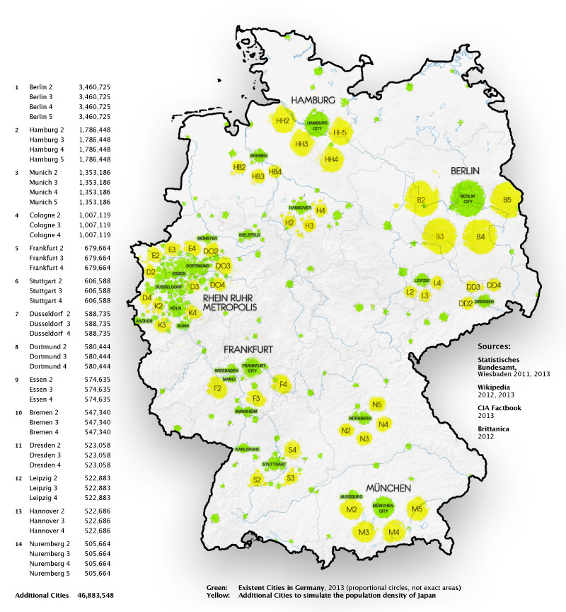
The answer is: one would have to add several new cities.
In fact… quite a few ;)
The largest city in Germany is Berlin with almost 3.5 million living there.
Let’s double that. In fact lets triple it. Heck lets build four more Berlins…. would that do it?
I can tell you right now what an absolute nightmare it would be for anyone in Berlin to conceive of it growing five times larger. But.. that will not be enough by far.
The next larger town is Hamburg at 1.78 million. Heck, lets make that five times larger.
Then comes Munich at 1.45 million. Five of those, please.
And that is not remotely enough - it would take quadrupling each of the next ten cities still!
Altogether you need to squeeze an extra 46.8 million people into Germany to equal Japan.
Japan is at rank 10 with 127,350,000 inhabitants
Germany is at rank 16 with 80,523,700 inhabitants
And note that this figure of over 50% more people is not only in the same area, but less! Large portions of Japan are rocky, steep and barely usable, making it all even more drastic.
Here this mental experiment is visualized by adding 46 copies of the 14 largest cities. Obviously the current inhabitants of these newly covered areas would be displaced further into the countryside.
In other words: Japan is has an extremely dense population compared to Germany.
Just one look at this map makes it very clear what a drastic change it would create if each major agglomeration were to grow in such a way. General living conditions, commuting to and from workplaces, travel, shopping, leisure time - everything would be hugely affected.
And then you have to stop for a moment and realize: that is exactly the case in Japan today! One simply has to think about how fundamentally different the entire society has to be, even just for this reason alone.
A few thoughts: please don’t get quite so overly literal. Every time I do one these there is a slew of responses that are apparently completely missing the point.
This is a symbolic visualization.
No - Berlin is not totally round.
The blobs are just roughly circles, proportional to the size.
No - The edges are not ‘bad Jpeg’s.
They are merely slightly diffused little blobs instead of perfect circles, that’s all.
No - In the yellow areas one does not have to ‘subtract’ anyone
Obviously the inhabitants of the newly overlayed areas would be displaced into the surrounding countryside. The whole idea is an additional 50%+
No - Düsseldorf’s Umlaut dots should not be deleted.
Even if it is common practice to neglect them in English.
‘Düssel’ is a small river leading to the Rhein, via the Neanderthal, actually.
Whereas as a ‘Dussel’ -without dots- is… a moron. So for dots sake, use them.
Inconsistently I left Cologne (Köln) and Munich (München)
probably somehow humoring the alienation factor. One step at a time…
No - This map is not inaccurate because town X Y or Z are missing.
It is in no way attempting to be depicting exact German topography.
The top 14 are reasonably there, roughly proportional, basically in the right spot. That will suffice entirely to tell the story here, which is in itself only an abstraction.
No - I did not forget that China has more people
Nor that Bangladesh is denser and Singapore even more… The point is not the absolute number. All of those are vastly different in size and thus the comparison is just not as visceral. I just chose Japan for that reason.
I bet you that this map will be recopied WITHOUT this second page - and that in the repostings and retweets you can find comments all over the place which will whine exactly like that about each and every one of these points! Somehow quite sad, the state of the net.
Final thought:
Just mentioning any numbers at all seems to bring out the pedantic sticklers from under their rocks, who have apparently nothing better to do than to scour through lists almost desperate to find if ‘someone is wrong on the internet’.
But of course it is trivial to find many different variations between the sources.
And even giving the source is not enough… Here is one
But quickly you find a footnote like this:
The ranking for world's third largest country is disputed due to
(1) conflicting information from different sources; and
(2) differing methods on how land and water areas are calculated.
The Encyclopædia Britannica lists U.S. as the world's fourth largest country
(after Russia, Canada, and China) with a total area of 9,526,468 km2 (3,678,190 sq mi)
The UN figure of (9,629,091 km2 or 3,717,813 sq mi)
includes coastal waters, but not territorial waters.
The CIA World Factbook fiqure of (9,826,675 km2 or 3,794,100 sq mi)
additionally includes territorial waters
See…? Can’t win...
I am intensely enamored with detail myself, but within reason and context and logical sense. A big difference between ‘subtle differentiation’ and…quibbling.
See..? Can’t lose… ;)